

12- Ishinomaki Kahoku April 8, 2018

<12>
Nakase and a Wagon
1951 Photograph by an American Military Doctor
Apr. 8th, 2018
Translation by Stefan Ramos
This is a photo of Naikaibashidori Street in Nakase which had gotten back up on its feet after the building removals in July of 1945 (Showa 20). ‘Building removals’ refers to the obligatory demolition of residential buildings and such with the goal of creating anti-fire rings in order to protect important establishments from fires caused by air raids.
From the left we can see Chibamishoten, Yokotatabakotsuriguten Tobacco and Fishing Supply Store, and the Yamanishi Firm; beside the telephone pole is the hill road that continues on to the northern end of Akiba Shrine. There were also shops in that area (is that one house the Kawasakitokeiten Clock Shop?), and one house can be seen in the harbor in the direction of eastern Naikaibashi. The brand-new glass door on Chibamishoten indicates its recent reconstruction.
On the right is the Okuda Theatre’s film board (title unknown). The Okuda Theatre, which was rebuilt after the war, changed its front from kabuki-style seating to a one-story style, and became a movie theatre in 1949 (Showa 24). The record-breaking hit, Godzilla, was screened in 1954 (Showa 29).
A wagon on Nakasedori Street is heading towards Minato. It’s not entirely clear what the cargo is, but because lots of furniture that look like tansu or other large chests has been loaded onto the cart, maybe they’re moving? The luggage has been wrapped in woven and rush mats to prevent injury. The coach frame is made of wood, a small front wheel, large back wheels, and a luggage platform. It was a revolving framework that made use of slight rotations of the front wheel.
Before long wagons became fewer and were superseded by automatic three-wheeled cars and automobiles, but horses were still used by farmers picking up septic tanks they had requested, wood and fuel transport, and pulling sleighs for timber felled in mountain forests.
In the 1959 (Showa 34) commerce and industry map in Kokucho there were still wheelwright and harness stores that made wagons. The drawback to wagons was the physiology of the horse; their excreting regardless of location, even mid-walk, was quite annoying. (Local Historian, Seiji Henmi)
<Please let us know if you have any information>
You can browse the published photos on the photographer’s eldest son, Alan Butler’s, website “Miyagi 1951”. https://www.miyagi1951.com/
Please feel free to contribute any information regarding these photos to Mr. Henmi at 090(4317)7706.
米軍医が撮った1951、石巻地方<12> 中瀬と荷馬車
1945(昭和20)年7月の建物疎開から立ち直った中瀬の内海橋通りです。建物疎開は、空襲による焼失から重要施設を守るため、防火帯を作る目的で行った住宅などの強制解体のこと。石巻市では中瀬と中町、本町などで実施されました。
写真左から、千葉三商店、横田煙草(たばこ)釣具店、山西商会で、電柱の脇から北端の秋葉神社への坂道が続いています。その先にも店があり(うち1軒は川崎時計店か)、東内海橋の先には湊の家が1軒見えます。千葉三商店の真新しいガラス戸が、直近の再建であったことを物語ります。
右にあるのは岡田劇場の映画看板(内容不明)。戦後、建物疎開から再建した岡田劇場は、正面が歌舞伎座風の造りから平屋に変わり、49(昭和24)年に映画常設館となりました。空前の大ヒットとなった「ゴジラ」の上映は54(昭和29)年です。
中瀬通りを荷馬車が湊方向に通過中。積み荷ははっきりしませんが、たんすか長持ちに見える家具類を荷台いっぱいに積んでいるので、引越し荷物でしょうか。傷を付けないようにゴザとムシロで囲っています。馬車の車体は木製で小さい前輪、大きい後輪と荷台からなり、前輪は小回りが利く回転構造でした。
やがて荷馬車は、オート三輪車や自動車に取って代わられて少なくなりますが、農家に依頼した便槽のくみ取り、木材や薪炭、馬草の運搬、馬は山林での木出しのソリ引きなどに利用されました。
59(昭和34)年の商工地図の中にも穀町には、荷馬車を製作する製車店や馬具店がありました。荷馬車の欠点は馬の生理現象で、歩行中でも所構わずの排せつには閉口させられたものでした。(郷土史家・辺見清二)
※米軍医が撮った1951、石巻地方<11> 四つ手網漁と定川
http://ishinomaki.kahoku.co.jp/news/2018/04/20180401t13002.htm
<情報をお寄せください>
掲載された写真は、撮影者の長男アラン・バトラー氏のウェブサイト「Miyagi 1951」で閲覧できます。https://www.miyagi1951.com/
写真に関する情報は辺見氏 090(4317)7706 にお寄せください。
11 - Ishinomaki Kahoku April 1, 2018

Jo River- Dipping Nets and the Jogawa in 1951 (#51, 2017.11.1.41)

Jo River (Jogawa) 2018

<11>
Nets and the Jogawa River
The 1951 Photographed by an American Military Doctor Dipping
Apr. 1st, 2018
Translated by Stefan Ramos
The present day Jogawa River (17km long) flows through the old Kyukanancho and Kyuyamotocho neighborhoods and fills up the Ishinomaki Port. Until the early days of the Meiji Period, because they originated from Araodake Mountain in Osaki City’s Naruko hot springs town in the Tamatsukurigun District there were rivers named things like Tamatsukurigawa, Araogawa, Eaigawa, or the Teruigawa River (which was named after a lord) that poured directly into the sea through the Omagari coast.
After Shigeyoshi Kawamuramagobe joined together the Eaigawa, Hasamagawa, and the Kitakamigawa rivers in 1616, because the water source was cut off in the old Kyukanancho Tatsunokuchi neighborhood the river was afterwards called the Jogawa River.
The Jogawa River, which flows across flat land, has at high tide an upstream flow of salt water. The masses of reeds that can be seen growing on either bank show how the brackish waters of mixing fresh and salt water cultivate the reeds in the slow-flowing river.
Along the Jogawa River at night there were also places where the work horses that labored all day long could wash themselves. Because [this author’s] mother’s family home was in front of the river in Minamiakai, he often went to the Jogawa River, but has a strange memory of wondering what those little huts on the water’s surface were. Before long he figured out that they were dipping net huts for catching river fish.
Dipping nets were square, bag-like nets onto which one would attach bait, that would be submerged under the water, and that would lure in the fish. Fishermen would look out from the huts for the fish to enter the net, and as this fishing gear would be lifted up the moment the fish entered it was one type of lift net. Using the same fishing methods on the Kitakamigawa River basin’s Hasamagawa and Narusegawa Rivers fishermen would aim for fish like koi, crucian carp, and catfish; in brackish waters they would aim for dotted gizzard shad [also called spotted sardines], small goby, or chum salmon that had returned to where they were born in the Kitakamigawa River around the prefectural border. In the 50’s of the Showa Period [1975-1985] dipping nets for whitebait fishing could be seen around Mangokuura.
It can be said that around 1951 (Showa 26) [Japan] broke out of the food shortage. The small fish caught by the dipping nets became dashi [a quintessential fish broth used in Japanese cooking] and a precious source of animal protein for the farmers who could not get fresh fish in inland areas. In many a sunken fireplace, kitchen, and roof could be seen benkei, grilled fish on bamboo skewers. (Local Historian, Seiji Henmi)
<Please let us know if you have any information>
You can browse the published photos on the photographer’s eldest son, Alan Butler’s, website “Miyagi 1951”. https://www.miyagi1951.com/
Please feel free to contribute any information regarding these photos to Mr. Henmi at 090(4317)7706.
米軍医が撮った1951、石巻地方<11> 四つ手網漁と定川
現在の定川(延長約17キロ)は、旧河南町と旧矢本町などを流れて石巻港に注ぎます。江戸時代初期までは、玉造郡(大崎市鳴子温泉町)の荒雄岳を源流としたことから、玉造川や荒雄川、江合川、領主名から照井川などと呼ばれて、直接、大曲海岸で海に注ぐ河川でした。
川村孫兵衛重吉が1616年、江合川、迫川、北上川の3川を合流した後、旧河南町龍ノ口付近で水源が断たれたことから、それ以降は定川と呼ばれています。
平たん地を流れる定川は、満潮時には海水が遡上(そじょう)します。川沿いの両岸に「ヨシ」の群生が見られるのは、流速が遅いことでヨシが生育する淡水と海水の混在する汽水域ができていることを示しています。
定川は夕刻、一日働いた農耕馬の体を洗い水浴びさせる所でもありました。母親の実家が南赤井の川前にあったので、子どもの頃、定川によく行きましたが、水面の小屋は何だろうと不思議な思いで見たものです。やがて川魚を漁獲する四つ手網小屋と知りました。
四つ手網は、正方形の袋状の網に餌を付けて水中に沈めておびき寄せ、魚が網に入るのを小屋で見張り、入った瞬間に引き揚げて漁獲する漁具で、敷網の一種です。北上川流域の迫川、鳴瀬川でも同様の漁法でコイ、フナ、ナマズなど、汽水域ではコノシロ、ハゼの小魚、北上川の県境付近では生まれた川に戻ってくるシロザケを狙い、昭和50年代には万石浦でシラウオの四つ手網漁を目にしています。
1951(昭和26)年ごろは食糧難から抜け出したとはいえ、四つ手網で漁獲された小魚は、内陸部で鮮魚が入手できない農家の貴重な動物タンパク源と「だし魚」となり、いろりや台所の天井には竹串に焼き魚を刺した「弁慶」の光景が見られたものです。(郷土史家・辺見清二)
10- Ishinomaki Kahoku March 25, 2018

<10>
In Front of the Senseki Line’s Ishinomaki Station
1951 Photographed by an American Military Doctor
Mar. 25th, 2018
Translated by Stefan Ramos
These are three rickshaws, used for carrying passengers, and their drivers in the plaza in front of Ishinomaki Station on the Senseki Line. We can see in the photo things like, on the right hand side, the old Shimizushokudo restaurant on the corner of the road in front of the station, towards the front what would later become Kasugachodori Road, and the three white bulbs of the suzuran streetlights that were installed by volunteers in front of the station in 1950 (Showa 25). Seeing the unpaved plaza in front of the station is a vivid reminder of the wooden station built in the Miyagi Electric Railroad Era which began in 1928 (Showa 3). The rickshaw driver’s clothes seem to be a hat halfway between a military hat and an ordinary cap, a military jacket and pants, a towel around his neck, and a pair of split-toed work tabi.
The picture shows the poverty of postwar Japan, a time of suffering when things were in short supply. The rickshaw is a vehicle invented by a Japanese person in the early years of the Meiji period [1868-1912] and was brought in to Ishinomaki as well. Looking back, there were rickshaw and stage coaches running in between Ishinomaki and Matsushima for people who were going to the capital.
Looking at a 1927 (Showa 2) telephone book, one will see “Naikai Rickshaw”; they were used for picking up house call doctors, geishas, and masters. This author who was born after the war has of course never ridden in one, neither has he ever seen one carrying passengers around. If anyone knows, please let us know until when rickshaws were used in Ishinomaki.
In July of this year [1951], shocking news came to Ishinomaki. Nineteen Japanese people who had not yet heard of Japan’s defeat were rescued from Anatahan Island in the Mariana archipelago and returned home. Within those nineteen people were the healthy captain of the navy-conscripted Kaihomaru no. 7, Katsusaburou Shirai, chief engineer Azuma Kumagai, and crewmember Sueji Kimura.
Because of the military clothing of the rickshaw driver this photo really feels like a scene from Ishinomaki’s forgotten postwar history. (Local Historian, Seiji Henmi)
<Please let us know if you have any information>
You can browse the published photos on the photographer’s eldest son, Alan Butler’s, website “Miyagi 1951”. https://www.miyagi1951.com/
Please feel free to contribute any information regarding these photos to Mr. Henmi at 090(4317)7706.
米軍医が撮った1951、石巻地方<10> 仙石線石巻駅前
仙石線石巻駅前の広場で、客待ちをする3台の人力車と車夫です。右手が駅前通り角の元清水食堂など、正面に後の春日町通りと、1950(昭和25)年に駅前有志が設置したすずらん灯、白いボールランプ3個の街路灯が見えます。 駅前広場は未舗装で、28(昭和3)年に開業した宮城電鉄時代の木造駅舎がほうふつされます。車夫の服装は、旧陸軍の軍帽ないしは略帽、上着とズボンは軍服、首に手拭い、履物は地下足袋のように見えます。 写真は、戦後の日本の貧しさ、物資不足に苦しむ時代そのものを映し出しています。人力車は明治初年、日本人が発明した乗り物で、石巻村にも導入されました。さかのぼると、上京する人のため石巻-松島間に人力車と駅馬車が運行しています。 27(昭和2)年の電話早見表を見ると、本町に「内海人力車立場」とあり、往診のお医者さん、芸者衆や旦那さん方の送迎に利用されました。戦後生まれの筆者は乗車経験はもちろんなく、客を乗せて走る姿も見てはいません。石巻市では乗り物の人力車がいつごろまで使われたのか、ご存じの方はお知らせください。
この年の7月、石巻市に衝撃的なニュースが飛び込みます。マリアナ諸島のアナタハン島から、日本の敗戦を知らないでいた日本人19人が救出されて帰国。その中に、海軍徴用船第7海鳳丸の白井勝三郎船長と熊谷東機関長、乗組員木村末治さんの石巻人の元気な姿がありました。
軍服の車夫の姿から、忘れ去られた石巻の戦後史の一コマを感じた写真です。(郷土史家・辺見清二)※米軍医が撮った1951、石巻地方<9> 町の書店http://ishinomaki.kahoku.co.jp/news/2018/03/20180318t13007.htm<情報をお寄せください> 掲載された写真は、撮影者の長男アラン・バトラー氏のウェブサイト「Miyagi 1951」で閲覧できます。https://www.miyagi1951.com/ 写真に関する情報は辺見氏 090(4317)7706 にお寄せください。
9-Ishinomaki Kahoku March 18, 2018

<9>
Town Bookstores
The 1951 Photographed by an American Military Doctor
Mar. 18th, 2018
Translation by Stefan Ramos
This author remembers the Tanshobo book store on Omachidori (his route to school) and the Kinkodoshoten book store (formerly the Suzukishoten book store) on the south side of the road.
The large signboard reading “Lady’s Living” and the banners in the photo really give the store some impact. “Lady’s Living” was launched in May of 1947 (Showa 22) and was followed by pioneer womens’ magazines like “Housewife and Life” in 1951, “The Housewife’s Friend” in 1952, and “Lady’s Club.” They made an effort at advertising like through the burden of creating a signboard, and apparently it had a tremendous impact on publicity.
Speaking of stores where a child could go by him or herself, within the town there were a few like Tanakoya or Tosukeya, the Omochaya toy store, the book-lending shop, or the stationary store, but parents would accompany children to the Marumitsu department store, the movie theatre and the hire boat spot, and the roller skating rink. The bookstore therein was a shop you could stop at by yourself.
Both bookstores had narrow fronts but went far back, and were laid out in a configuration where bookshelves encircled a center island. The store was poorly lit and had dirt floors. I remember the payment area being towards the back. I probably felt that the store was so big because I was small.
The postwar juvenile magazine “Elementary School __ Grader” was reissued in 1946 (Showa 21), and was followed in quick succession by new publications like “Manga Boys” in ’47, “The Adventure King” in ’49, “The Girl Student’s Friend” in ’50, “Good Friends” in ’54, “Ribbon” in ’55, “Boy’s Magazine Weekly” and “We Are the Boys Club” in ’60. Special editions of monthly magazines was also something everyone enjoyed.
I couldn’t buy them with my own money, but it was worth it to just look at the magazines. I'd read while standing, flipping through the pages, just looking. Kinkodo moved from Omachi to Tachimachodori Street. At the corner of Tachimachi and the road in front of the station there was a Yamatoshoten book store, so I would read a bit at one store then move to the next and read a bit more until I had finished the story.
Another memory I have of the book store is textbook sales. In the Ishinomaki Elementary school auditorium there was a textbook book fair. The memory is vague, but I think afterwards I would head into town and buy textbooks there. (Local Historian, Seiji Henmi)
<Please let us know if you have any information>
You can browse the published photos on the photographer’s eldest son, Alan Butler’s, website “Miyagi 1951”. https://www.miyagi1951.com/
Please feel free to contribute any information regarding these photos to Mr. Henmi at 090(4317)7706.
米軍医が撮った1951、石巻地方<9> 町の書店筆者の通学路の大町通りには耽書房と、南側に金港堂書店(前身は鈴木書店)があったと記憶しています。
写真の「婦人生活」の大看板とのぼりが店舗にインパクトを与えています。「婦人生活」は1947(昭和22)年5月の創刊で、51年の「主婦と生活」、52年の「主婦の友」「婦人倶楽部(くらぶ)」など婦人雑誌の草分け。看板作製の負担などのPRに努めて、絶大な宣伝効果を上げたようです。
子どもが一人で行ける店と言えば、町内の店子(たなこ)屋とかトスケ屋、おもちゃ屋、貸本屋、文具店などと少なく、丸光デパート、映画館や貸しボート、ローラースケート場は親と同伴でした。その中で本屋は一人で寄れる店でした。
両書店とも間口が狭いが奥行きが深く、島型の中心部の書棚を周囲の棚が囲む配置でした。床は舗装していない土間で、店内は薄暗く、支払いは奥の方と記憶していますが、売り場が広く感じたのは自分が小さかったからでしょうか。
戦後の少年少女向け雑誌として「小学○年生」は46(昭和21)年に復刊、「まんが少年」(47年)、「冒険王」(49年)、「女学生の友」(50年)、「なかよし」(54年)、「りぼん」(55年)、「週刊少年マガジン」「週刊少年サンデー」(59年)、「ぼくら・少年クラブ」(60年)などが相次いで発刊され、月刊雑誌の付録も楽しみの一つでした。
自分のお金では買えませんが、雑誌は見るだけでも値打ちがあってペラペラと立ち読み、ただ見をしたものです。金港堂は、大町から立町通りに移転。立町と駅前通り角にヤマト書店があり、書店のハシゴで完読したものです。
また、本屋の思い出は教科書の販売。石巻小は講堂内に書店が出張販売しました。記憶があいまいですが、後には市内の書店に出向いて購入したように思います。(郷土史家・辺見清二)
※米軍医が撮った1951、石巻地方<8> 大曲閘門
http://ishinomaki.kahoku.co.jp/news/2018/03/20180304t13008.htm
<情報をお寄せください>
掲載された写真は、撮影者の長男アラン・バトラー氏のウェブサイト「Miyagi 1951」で閲覧できます。https://www.miyagi1951.com/
写真に関する情報は辺見氏 090(4317)7706 にお寄せください。
8- Ishinomaki Kahoku March 4, 2018


<8>
The Omagari Lock Gate
Photographed in 1951 by an American Military Doctor
Mar. 4th, 2018
Translated by Stefan Ramos
In the above photo are two hirata boats and a motor boat passing through the Omagari lock gate (which used to be called the Jogawa River southern lock gate) in the Kitakami canal. They are continuing on towards the direction of the Narusegawa River (in the background of the photo). In the bottom photo is a family helping with the lock gate guard’s work of opening and closing the gate. The one-story building on the right is the guard’s official residence.
Along the Kitakami canal, which extends 13.9 kilometers and connects the Narusegawa and Kyukitakami Rivers, there are differences in water levels. The water level on the canal side is lower, so ship navigation becomes dangerous during high tide. The lock gate was installed with the objective of regulating these water levels.
In 1907 (Meiji 40), a wooden lock gate was established at the converging waterways of Kama and Omagari on either side of the Jogawa River with the objective of preventing sediment influx and counter-currents during floods. Because of the destruction from the high tide in 1913 (Taisho 2), a second concrete lock gate was built and construction finished in 1916 (Taisho 5).
The double doors of the lock gate are made of wood. The gates were opened and closed by turning a man-powered device called a kagurasan (capstan). The origin of the word kagurasan is unknown, but the framework is set up with squared timber. There is a thick log in the middle that acts as an axis; into the axis are inserted two wooden poles that when pushed by people would wind up the rope connected to the top part of the doors. This would open and close the doors. There was one kagurasan attached to each door, so this work would happen on the other river bank as well.
After the Meiji period small-sized steamboats went into commission on the canals. As a water route that connected the Shiogama and Ishinomaki ports, the Kyukitakamigawa River basin transported people and goods. Even after the war into the 30’s (1955-1964) of the Showa period, one could see the tranquil scene of motorboats pulling hirata boats carrying building materials like wood, river sand, and well stones.
The doors of the Omagari lock gate were switched with steel doors in 1966 (Showa 41), and many remember the mechanization of the opening and closing equipment. It is unknown for how long the prefecture stationed a guard there, but the gate deteriorated, lost the ability to open and close, and was removed. Now sometimes boats coming and going choose to sail at high tide. (Local Historian, Seiji Henmi)
<Please let us know if you have any information>
You can browse the published photos on the photographer’s eldest son, Alan Butler’s, website “Miyagi 1951”. https://www.miyagi1951.com/
Please feel free to contribute any information regarding these photos to Mr. Henmi at 090(4317)7706.
米軍医が撮った1951、石巻地方<8> 大曲閘門
上の写真は、北上運河の大曲閘門(こうもん)(旧名は定川南閘門)を通過する発動機船と、ひらた船2隻。鳴瀬川の方向(写真奥)に向かって進んでいます。下の写真は、閘門看守人の開閉作業を手伝う家族。右手にある木造平屋の建物は官舎です。
旧北上川と鳴瀬川を結ぶ北上運河(延長13.9キロ)の間には、水位差があって運河側の水位が低く、満潮時は船舶航行が危険になります。このために水位調節を目的に設置するのが閘門です。
県は1907(明治40)年、定川を挟んで運河が合流する釜と大曲に、土砂流入・洪水逆流防止の目的で、木造閘門を新設しました。13(大正2)年の高潮被害で損壊したためコンクリート積み閘門(2代目)を新築し、16(大正5)年7月に完工します。
閘門の門扉は、木製で観音開きです。「神楽桟・かぐらさん」(ろくろ又は巻き車)と呼ばれた道具を人力で回転させて開閉します。
神楽桟の語源は不詳ですが、角材で枠を組み、中央に回転軸となる太い丸太を立て、軸に差し込んだ2本の木の棒を人力で回すことで門扉上部に連結したロープを巻き取り、開閉します。門扉1枚に1台の神楽桟が付属し、対岸でも作業中です。
運河には明治以降、小型蒸気船が就航。北上川流域と石巻港・塩釜港を結ぶ水上交通路として人と物を運びました。戦後も昭和30年代まで木材、川砂や井内石の建築資材を積むひらた船を発動機船が引く、のどかな光景が見られました。
大曲閘門の門扉は1966(昭和41)年、鋼製門扉と交換、開閉装置が機械化されたと思われます。県が看守人をいつごろまで配置したか不詳ですが、現在は老朽化から開閉機能を失って門扉が撤去され、たまに往来する船は満潮時を見計らい航行しています。(郷土史家・辺見清二)
7 - Ishinomaki Kahoku February 25, 2018

<7>
The View from Mt. Haguro
Photographed by an American Military Doctor, 1951
Thanks to Stefan Ramos for the translation
Feb. 25th, 2018
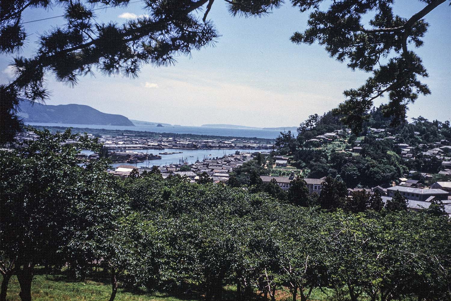
With Toriyajinja Shrine on the peak of urban Ishinomaki’s Mt. Haguro to the viewer’s back, this picture looks out towards Mt. Hiyori and the mouth of the Kyukitakamigawa River.
This photo was taken around the large lantern in front of the shrine grounds and near the front stairs. If you look out southwards from the 49-meters-tall Mt. Haguro, Mt. Hiyori (61 meters tall) acts as a wall and blocks off part of the view.
Just in front are over-crowded, fully grown cherry blossom trees. They were probably planted before the war.
We can also see buildings like the old Kyuishinomakishiyakusho city hall (a two story wooden building) which burned down in a fire in 1956 (Showa 31) and the old Monouoshika office and education center which was on the other side of the road and also a wooden building.
More buildings were being constructed on the Monomizaka hill on the east side of the old town hall and on the hill to the west in front of Kaimonji Temple; the conversion to residential land continued on. The creation of residential lots in Umegaoka and the beginning of the real estate sales happened afterwards. Shops and shipbuilding factories stood in a row down the Nakamachi, Honmachi, and Kadonowakicho riverside neighborhoods.
We have a glimpse through the shade of the trees of the activity in Nakase (a shipyard).
In 1951 (Showa 26) with the designation of Ishinomaki as a Category 3 Fishing Port, harbor maintenance progressed onwards. In the Minato area on the opposite shore we can see the long roof of the fish market and the completed pier.
The dredger permanently stationed in the port at this time continued dredging as it had every year in order to maintain the water depths of the boat routes and estuary. Before long the change to larger size fishing vessels continued, and through seeing the spreading and resumption of fishing industries moving from offshore to deep sea and northern-sea fisheries, we see the development of the fishing industries. The estuary port was reaching its limit, and in 1974 (Showa 49) the Ishinomaki port moved to Nagahama.
The pine grove that continued along the oceanic coast from Watanohacho to Nagahama was lost with the opening of the new Ishinomaki port and the establishment of the seafood product processing center, but in the picture we see the belt-shaped white sand and green pine grove. In the unchanging scenery of the Oshika Peninsula ridgeline and Bentenjima Island off the coast of Kotakehama, as well as Tashirojima Island and Ajishima Island, we feel the breaths of an Ishinomaki growing as a commercial fishing town. (Local Historian, Seiji Henmi)
<Please let us know if you have any information>
You can browse the published photos on the photographer’s eldest son, Alan Butler’s, website “Miyagi 1951”. https://www.miyagi1951.com/
Please feel free to contribute any information regarding these photos to Mr. Henmi at 090(4317)7706.
2018.02.25
米軍医が撮った1951、石巻地方<7> 羽黒山から
石巻市の市街地にある羽黒山頂の鳥屋神社を背にして、日和山や旧北上川河口方面を見た写真です。
撮影場所は、境内前の大灯籠近くの表参道階段付近。標高49メートルの羽黒山から南方向を望むと、日和山(61メートル)が壁となって一部の展望が遮られます。
手前は過密に成長した桜。植樹は戦前のことでしょうか。
その先に、1956(昭和31)年に火災で焼失した旧石巻市役所(木造2階)と、道路を挟んで同じく木造2階の旧桃生牡鹿事務所・同教育会館などが見えます。
旧市役所東側の物見坂、西側の海門寺前坂にも建物が建って、宅地化が進んでいます。梅が丘の宅地造成と分譲開始はこの後です。川岸沿いの中町、本町、門脇町には、商店と造船関連工場などが立ち並んでいました。
緑陰の間から中瀬(造船所)の活況がうかがえます。
51(昭和26)年は、第3種漁港の指定で港湾整備が進みました。対岸の湊地区には、完成した桟橋と魚市場の長い屋根が見えます。
港内に常駐する浚渫(しゅんせつ)船がこの頃、河口と航路の水深維持のため毎年のように浚渫を続けていました。やがて漁船の大型化が進み、漁船漁業が沖合から遠洋・北洋漁業の再開へと拡大を見せる中で、水産業界は発展。河口港は限界を迎え、石巻港は74(昭和49)年に長浜に移転します。
渡波町から長浜に続く海岸にあった松原は、石巻新漁港の開港と水産加工団地の開設で失われますが、写真には白砂青松の松原が帯状に見えます。牡鹿半島の稜線と小竹浜沖の弁天島、田代島と網地島の変わらない景色の中に、水産商港都市として成長していく石巻市の息吹が感じられます。(郷土史家・辺見清二)
※米軍医が撮った1951、石巻地方<6> 石巻小の遊動円木
http://ishinomaki.kahoku.co.jp/news/2018/02/20180218t13004.htm
<情報をお寄せください>
掲載された写真は、撮影者の長男アラン・バトラー氏のウェブサイト「Miyagi 1951」で閲覧できます。https://www.miyagi1951.com/
写真に関する情報は辺見氏 090(4317)7706 にお寄せください。
6 - Ishinomaki Kahoku February 18, 2018

<6>
Ishinomaki Elementary Swinging Pole
1951 Photograph by an American Military Doctor
Thanks to Stefan Ramos for the translation
Feb. 18th, 2018
The school gate of the Ishinomaki Elementary faced the road in front of the old Kyuishinomaki Town Hall that was built in 1917 (Taisho 6). The main and secondary gates were made up of four white granite poles, and if you entered the school grounds on the right-hand side towards the back was playground equipment.
In the picture, the children are gathered around a “swinging pole.” Many remember the nearby jungle gym and slide, and the horizontal bars in the front of the school. You won’t notice the swinging pole there anymore. Since there were chains fixed to the props on both ends of the thick log, it was a toy that hung horizontally and would graze the surface of the ground. It could be enjoyed like a swing swaying forwards and backwards.
The log that the kids would sit on was quite large so several children could ride at the same time. There was no place to grab onto the log, so it was difficult for the younger children to not fall off if someone shook it. With envious eyes they watched the skilled older children.
One day, the log toy was suddenly dismantled and disappeared. Maybe it was taken down during regular maintenance?
Behind the log toy is the newly built Ishinomaki community center, and there is a long stairwell stretching down from the second-floor emergency exit.
Because of an official notice from the national government, in June of 1947 (Showa 22) the community center leased the second floor of the Kankeimarushoten store on Omachidori Street and reopened. In June of 1949 at the site of the old Kyuishinomaki Town Hall in Yatsuzawa (currently Yatsuzawakoen Park) a new wooden mortar, two story building was constructed and the community center reopened there as the first independent community center in the prefecture.
This writer, a graduate of Ishinomaki Elementary, would take a field trip after school and stop by to visit the different exhibitions. This community center is filled with memories of walking around the building with shoes still on.
• By Local Historian, Seiji Henmi
<Please let us know if you have any information>
You can browse the published photos on the photographer’s eldest son, Alan Butler’s, website “Miyagi 1951”. https://www.miyagi1951.com/
Please feel free to contribute any information regarding these photos to Mr. Henmi at 090(4317)7706.
米軍医が撮った1951、石巻地方<6> 石巻小の遊動円木
旧石巻市役所前の通りに面した石巻小の校門は1917(大正6)年の建築で、正門と副門の4本の白御影石からなり、校庭に入ると右手の奥の方に遊具がありました。
写真で、子どもたちが集う遊具は「遊動円木」です。近くのジャングルジムと滑り台、正面校舎前の鉄棒などが思い出されます。
遊動円木は、今は見掛けなくなりました。太い丸太の両端を、支柱に固定した鎖で、地面スレスレに水平につり下げた遊具で、前後に揺すってブランコのように乗って楽しみます。
尻を乗せる丸太は太く、大勢の子どもが一度に乗れます。円木にはつかまる所がなく、大きく揺すると低学年の児童にはバランスをとって落下しないようにすることが難しく、乗りこなす上級生を羨望(せんぼう)の目で見ていたものです。
遊具は、ある日突然、取り外されて無くなることがありました。定期的に点検整備されていたのでしょうか。
遊動円木の後方にあるのは、当時、新築間もない石巻市公民館で、2階非常口から外階段が延びています。
同公民館は1947(昭和22)年の国の通達に基づき同年6月、大町通りの観慶丸商店2階を借り上げて開館。49(昭和24)年6月に旧石巻町役場跡の八津沢(現八つ沢公園)に木造モルタル2階建て、県内初の独立公民館として新築開館しました。
石巻小OBの筆者は下校時に立ち寄り、各種展示会などを見学しました。靴履きのままで館内を歩き回れた思い出あふれる公民館です。(郷土史家・辺見清二)
5- Ishinomaki Kahoku February 11, 2018


<5>
Kim Da Ru Street Ishinomaki District
taken by US military doctor, 1951
(temporary English Translation)
2018.02.11
Kimpira street, where Satomi head office and Mikiya head office used to be, connects the former back town (Omachi) street with the former Nakamachi Street, the river bank of the former Kitakami River. The street history dates back to the Edo era and was called "Yagiya Dingo" on the way to Ishinomaki Nakamachi and "Minamura Tamachi / Honmachi" on the other side of the former Kitakami River on the way to "Nakamachi".
When the Utsumi bridge came over in the Meiji era, when a fish market opened in Nakase, fresh fish traders and Kamaboko (Kamaboko) traders gathered, and the Ishinomaki's kitchen as Ishinami Town · boiled town with "Sarukoya side street" It will be a town to cover.
In March 1951, Mr. Kiyosaku Kikuchi in the town became the promoter and worshiped Shinko's Kaneda Rira (Shrine) Shrine, and in the residence on the south side of the street Kim Dora Shrine (Ishinomaki Small old former worship residence reuse) established. We will revise the street name with the approval of the town and neighborhood.
The luxurious gate at the entrance to the street was established in early April. The upper line is "Shinshan Kanpira-dori", the pillars on both sides are read as "entrance to Gala Dragon shrine full of fruitful harvest", "Shopping is in this city of sincere and inexpensive", expectation to the new town name, spirit You can feel it. Sakurai clothing store on the right side of the entrance, Chrysanthu shop on the fresh fish character, "Kimura shop" on the left (after furniture store).
The concrete well below the left gate is the old well well known in the old backyard. In the Boshin war, former shogunate army soldiers who missed Enomoto fleet headed to Hakodate were executed by the new government forces. In the vicinity of this well, there is a sad history that became the place of the two prisoners' heads of the city along with the Hijokoji high-bid place.
The width of the road is different near the well, and it is a town border. The wide road in front of the well is the old back street, the narrower one is the old middle side, the end is Ishiyama of Gomatsuyama. (Regional historian / Seiji Hemi)
※ U.S. military doctor took 1951, Ishinomaki district <4> Omako Beach and bay
http://ishinomaki.kahoku.co.jp/news/2018/02/20180204t13011.htm
<Please give us the information> The posted photos are taken at the website of the photographer's eldest son Alain Butler "Miyagi 1951" You can browse. https://www.miyagi1951.com
Information on photographs, please contact Mr. Homemi 090 (4317) 7706.
2018.02.11
米軍医が撮った1951、石巻地方<5> 金毘羅通り
かつてサトミ本店や三木屋本店があった金毘羅(こんぴら)通りは、旧裏町(大町)通りと旧中町通り、旧北上川の川岸を結びます。通りの歴史は江戸時代までさかのぼり、石巻村中町と旧北上川対岸の湊村田町・本町を結ぶ「中の渡」(中町渡)への道で、「八百屋丁」と呼ばれました。
明治期に内海橋が架かり、中瀬に魚市場が開設されると鮮魚商や蒲鉾(かまぼこ)業者が集まり、サルコヤ脇の横町とともに「肴(さかな)町・煮肴町」として石巻人の台所を賄う町となります。
1951(昭和26)年3月、町内の海産物商菊地清作氏が発起人となり四国の金刀比羅(ことひら)神社を分祀(ぶんし)し、通り南側の屋敷内に金毘羅神社(石巻小の旧奉安殿再利用)を創建。町内と近隣の賛同を得て通り名称を改めます。
通り入り口の豪華な門は、4月上旬に設置。上段は「肴町 金比羅通」、両側の柱は「五穀豊穣(ほうじょう) 大漁満船 金毘羅神社入口」、「お買物は誠実と廉価の此の街で」と読め、新町名への期待、心意気が感じ取れます。入り口右側はサクライ洋品店、鮮魚の文字は菊清商店、左側は「木村商店」(後の家具店)。
左の門柱下のコンクリート井戸は、旧裏町で最も良く知られた古井戸です。戊辰戦争では、箱館に向かう榎本艦隊に乗り遅れた旧幕府軍兵士らが新政府軍によって処刑されました。この井戸の付近は、広小路の高札場とともに市内2カ所のさらし首の場所となった悲しい歴史があります。
井戸付近で道路幅員が異なっており、町境となっています。井戸前の広い道が旧裏町、奥の狭い方が旧中町側、突き当たりは五松山の石山です。(郷土史家・辺見清二)
※米軍医が撮った1951、石巻地方<4> 大曲浜と入り江
http://ishinomaki.kahoku.co.jp/news/2018/02/20180204t13011.htm
<情報をお寄せください>
掲載された写真は、撮影者の長男アラン・バトラー氏のウェブサイト「Miyagi 1951」で閲覧できます。https://www.miyagi1951.com/
写真に関する情報は辺見氏 090(4317)7706 にお寄せください。
Ishinomaki Kahoku February 4, 2018

<4> The 1951 Photograph by an American Military Doctor, Shows The Omagarihama Beach and Inlet
Feb. 4th, 2018
The Ishinomaki Harbor construction utilizing the Kama region inlet began in 1961 (Showa 36) and was completed in 1967 (Showa 42). The estuary scenery of the inlet being filled by the Jogawa River completely changed.
The photograph is a view of grandchildren and an old woman carrying small fish on Omagari Beach which faces the inlet. The two in the foreground have stuck an oar, as though it were a carrying pole, through a bamboo basket and a tin bucket with fish, shouldered it, and are moving. In the background can be seen the figure of a young woman holding a bucket or something.
The Omagari Beach coastal levees (breakwater embankments) appear low, but if you ask Kama residents who know about the old Omagari Beach they will tell you that’s right; this [picture] shows the contrast of the pine trees that had grown tall. The water in the background is the inlet in Kadonowaki in Kama, and the middle of the Jogawa River filling the inlet was the border between Ishinomaki City and the old Kyuyamotocho Town.
The Kamanowatashi Ferry used to come and go here, carrying shoppers and peddlers by boat towards Ishinomaki.
For as long as anyone can remember there has been a deep connection between the Omagari and Kama regions; for marriages the saying “the Kama man and the Omagari woman” remains [even today]One of the chimneys from Tohoku Pulp (currently the Nippon Paper Group’s Ishinomaki factory) can be seen below the mountain ridgeline in the back which looks out in the direction of Ishinomaki. A south (ocean) wind is blowing, and since the smoke is trailing inland this may have been around the beginning of summerThe Kama inlet was a place where children would be taken by their parents to go fishing and shell-collecting, and many remember the pine grove encircling the bay. At the beginning of the Edo period, due to confluence construction by Shigeyoshi Kawamuramagobe [a samurai who became a flood control specialist], the Eaikawa River (Jogawa River), the Hazagawa River, and the Kitakami River stopped flowing into the sea and were established as a lagoon and tidal flat
Omagari was a prosperous district for the salt-making and fishing industries. As a gift from Mr. Kawamuramagobe, Kamaomagari (an exclave of Omagari Beach) within Kadonowaki was incorporated into Kadonowakimura Village from Omagarimura Village as the Kama region. The region’s name, Kama, comes from the [Japanese word for] pot used in salt-making.
<Please let us know if you have any information>
You can browse the published photos on the photographer’s eldest son, Alan Butler’s, website “Miyagi 1951”. https://www.miyagi1951.com/
Please feel free to contribute any information regarding these photos to Mr. Henmi at 090(4317)7706.

1955 Military Map

2018 Satellite Map

Photo of Area Shortly After Tsunami
米軍医が撮った1951、石巻地方<4> 大曲浜と入り江
石巻工業港は1961(昭和36)年、釜地区の入り江を利用した堀込港湾として着工され、67(昭和42)年に開港。定川が入り江に注ぐ河口の景色は一変しました。
写真は、入り江に面した大曲浜で小魚を運ぶ老婦人と孫たちの光景です。手前の2人は、魚を入れたブリキのバケツと竹籠を天秤(てんびん)棒ならぬ船の櫂(かい)に通し、担いで運搬。後方にもバケツか何かを手にする少女の姿が見えます。
大曲浜の海岸堤防(波よけ土手)が低いように見えますが、大曲浜の昔を知る釜の住民に尋ねると「その通りです」と話してくれて、大きく成長したマツの木と対比を見せています。後方の海面は門脇の釜の入り江で、入り江に注ぐ定川の真ん中が石巻市と旧矢本町の境界線でした。
かつては「釜の渡」が往来し、石巻方面への行商人や買い物客を船で運んでいました。
古来、大曲と釜地区の関係は深いものがあり、婚姻先として「釜男と大曲女」のことわざが残ります。
石巻方向を望む奥の稜線(りょうせん)の下に東北パルプ(現日本製紙石巻工場)の煙突が1本見えます。南風(海風)が吹き、陸地に向けて煙がたなびいているので、初夏の頃かもしれません。
釜の入り江は、子どもが親に連れられて釣りや貝拾いをした場所で、入り江を囲む一面の松原が思い出されます。江戸時代の初め、川村孫兵衛重吉による江合川(定川)、迫川と北上川との合流工事により、海に注ぐ水流を失い「潟湖(かたこ)干潟」として成立しました。
大曲地区は製塩業と漁業が盛んでした。釜地区は、門脇のうち「釜大曲」(大曲浜の飛び地)を川村氏が拝領したことで大曲村から門脇村に編入されました。地名の釜は製塩釜の釜に由来して今日に至っています。(郷土史家・辺見清二)
※米軍医が撮った1951、石巻地方<3> 大町通り
http://ishinomaki.kahoku.co.jp/news/2018/01/20180128t13010.htm
<情報をお寄せください>
掲載された写真は、撮影者の長男アラン・バトラー氏のウェブサイト「Miyagi 1951」で閲覧できます。https://www.miyagi1951.com/
写真に関する情報は辺見氏 090(4317)7706 にお寄せください。
Ishinomak Kahoku January 28, 2018

Women's Clothing Reflecting Society
The 1951 Photographed by an American Military Doctor
Ishinomaki, Omachidori Street
Jan. 28th, 2018
This picture is of the neighborhood on the north side in front of Kankeimarumototen on Omachidori Street (currently Aitopia). It can be seen from the clothing of the passersby that it was either spring or autumn time. Captain Butler stood in this spot and took several photos.
One can see that the shops on the west side of the street are Tokyoyahakimonoten shoe store, the stallholders in tents pitched in the empty lot in front of the Ishinomaki Chamber of Commerce and Industry, Hamayayohinten Western goods, and Kameshichigofukuten Japanese cloth store. On both sides of the street are a forest of banners, and if one looks at the end of the street he will see all of the people in front of the street stalls; it is surprising to see so many pedestrians here.
To the North side of Tokyoya[hakimonoten] are the Ishidakanamonoten hardware, Marunao, Somayakaguten furniture, Kankeimarushoten, Sutoaramonoya variety, and Tanshobo shops, etc. The models in these successive shots are women glimpsed in the streets of Ishinomaki. Amongst them are a young woman, a lady with her child, and some sisters. It seems that Captain Butler, who visited many places, noticed the different appearance and clothes of women in various areas (urban districts, farming villages, and fishing villages), industries, and occupations.
Most men wore western clothes, but women mixed Japanese and Western clothes. The three good friends that can be seen [in this photo] if they are still alive would be in the latter half of their eighties, wouldn’t they? The woman with the white sweater and skirt has good taste, but it’s a pity that she is wearing geta (traditional wooden Japanese clogs).
This was a year when nylon socks were in vogue, but throughout the country everything was in short supply so shoes were a valuable. It was a time when even though people wanted things they just could not get their hands on them.
The following year Omachi and Omachiginzadori Street charged ahead of other towns and began installing asphalt roads. There were memorial sales, and in both name and substance [the area] fully developed as a shopping district. (Local historian Seiji Henmi)
※The 1951 that an American Military Doctor Captured Kawahiraki and Tachimachidori Street
http://ishinomaki.kahoku.co.jp/news/2018/01/20180121t13006.htm
<Please let us know if you have any information>
You can browse the published photos on the photographer’s eldest son, Alan Butler’s, website “Miyagi 1951”. https://www.miyagi1951.com/
Please feel free to contribute any information regarding these photos to Mr. Henmi at 090(4317)7706.
米軍医が撮った1951<3> 石巻・大町通り
写真は、石巻市大町通り(現アイトピア)の観慶丸本店前の北側付近。通行人の服装から、時期は春か秋ごろとみられます。バトラー大尉はこの場所で立て続けに数カットの写真を撮影しています。
通り西側店舗は東京屋履物店、石巻商工会議所前の空き地にテント掛けの露天商、はまや洋品店、亀七呉服店が見えていて、道路両側に「のぼり」が林立し、通りの先を観察すると露店前の人だかり、人通りの多いことに驚きます。
東京屋北側は石田金物店、丸直、相馬屋家具店、観慶丸商店、須藤荒物屋、耽(たん)書房などの店舗。数カットのモデルは石巻の街で目にした日本人女性のうち、若い女性、子ども連れの婦人や姉妹たちです。各地を訪れたバトラー大尉は、地域(町場、農村、漁村)、産業、仕事内容などによって女性たちの服装や容姿が違うことに気付いたようです。
男性の大半が洋服ですが、女性は和服と洋服が混在しています。仲良しの3人組に見える女性たちは、健在であれば80代後半になるでしょうか。白セーターとスカート姿の女性は際立つセンスの持ち主ですが、足元の履物がげたであることが残念です。
この年はナイロン靴下が流行した年ですが、国内中で全ての品物が不足して靴は貴重品。欲しくても手に入らない時代でした。
翌年、大町・大町銀座通りは他町に先駆けてアスファルトの道路舗装に取り掛かり、記念売り出しを実施、名実ともに市内の繁華街として発展を遂げます。(郷土史家・辺見清二)
※米軍医が撮った1951<2> 川開きと立町通り
http://ishinomaki.kahoku.co.jp/news/2018/01/20180121t13006.htm
<情報をお寄せください>
掲載された写真は、撮影者の長男アラン・バトラー氏のウェブサイト「Miyagi 1951」で閲覧できます。https://www.miyagi1951.com/
写真に関する情報は辺見氏 090(4317)7706 にお寄せください。
Ishinomaki Kahoku January 21, 2018

Ishinomaki Utsumi Bridge Commercial Street 1951
The 1951 Photographed by an American Military Doctor
Kawahiraki and Tachimachidori Street
Jan. 21st, 2018
This photo is one view of the 1951 (Showa 26) Ishinomaki Kawahiraki Festival [a festival that marks the start of boating season] which was held on July 28th and 29th (Sat.).
Having been stopped since the outbreak of the Second Sino-Japanese War in 1937 (Showa 12), the Kawahiraki Festival was revived in 1946 (Showa 21) after the Pacific War. Based on the simple Tanabata Star Festival decorations on Tachimachidori Street and the back road leading to Toriya Shrine which is in front of the stone torii gate (which was damaged by an earthquake in the sea off of the coast of the Miyagi prefecture and moved to the grounds of Toriya Shrine) we know that this was one of the Kawahiraki Festival days.
On this day the one-way Tachimachidori Street had been blocked off to cars. Without expecting streamers or kusudama (decorative paper balls used during festivals, etc.) like the ones on Omachidori Street, a tunnel made of colored paper strung from small bamboo plants was the best they could do. With the modest, small bamboo plants, it was a time when [everyone] felt the joys of festivals and peace.
Below the 200+ stone steps the road from the old Kyuoikawanaika internist to the old Kyunakajimageka surgeon is unclear, but it had already been built. The Tachimachi shops from the left are Fukuraikanshashinkan photo studio, several houses down between the reopened Taigetsushokudo restaurant and the red and white curtain of the Western building is a roof (a gateway?) to the entrance of Fukichodori Street. To the right of that is the Akitaya mansion and the large ginkgo tree in the gardens, several storehouses, and Miyoshi Shrine.
The new two story building is the prefectural Public Healthcare Center, and with the large storehouse-like roof and chimney as a landmark we understand that
to the right behind Akitaya is Shindencho’s Kinkabuto, Suzukishoyuya soy sauce shop, and Suminoe sake brewery, etc.
There are two festival performance tents standing in the remains of Akitakoen Park in front of Fukicho, and beginning in May of this year the Kigura Circus was performing. Aren’t there several people who remember the crowded circus tents on that festival day? Several years later the remains of Akitakoen Park were sold off and it changed into the Ekimae Market, but there are now few left of the generation that knows of the market.
It is thought that at the upper end [of the photograph] are Ogawa railroad crossing and the northern end of Asahimachidori Street. To the left of the Asahimachi railroad crossing can be seen the Takayashikido Road which runs along the Hebitahori trench. Before long, around 1955 (Showa 30), the adjustment of arable land behind the station was completed and the Hebitahori trench was made into a straight line near the Ishinomaki Line. In this year the North-South road of the Mizuoshi railroad crossing in front of the Niinumakanamonoya hardware store in Kokucho was put in place.
※The 1951 that an American Military Doctor Captured Ishinomaki, Naikaibashidori Shopping Street
Please let us know if you have any information>
You can browse the published photos on the photographer’s eldest son, Alan Butler’s, website “Miyagi 1951”. https://www.miyagi1951.com/
Please feel free to contribute any information regarding these photos to Mr. Henmi at 090(4317)7706.
米軍医が撮った1951<2> 川開きと立町通り
1951(昭和26)年の石巻川開き祭りは7月28、29日の土日開催で、写真は当日の一景です。
日中戦争の開戦で37(昭和12)年から休止していた川開き祭りは、太平洋戦争後の46(昭和21)年に復活。石鳥居(宮城県沖地震で損壊し鳥屋神社境内移転)前の鳥屋神社裏参道や立町通りの簡素な七夕飾りから、川開きの一日と分かります。
この日、一方通行の立町通りは歩行者天国となり、大町通りのようなくす玉や吹き流しは望めず、笹竹に色紙テープのトンネルをつるすのが精いっぱい。ささやかな笹竹に、平和と祭りの喜びを感じた時代です。
二百余段の石段の下、旧及川内科から旧中島外科への道路がはっきりしませんが、既に開通しています。立町の店舗は左から福来館写真館、数軒目は再開した待月食堂で、洋風建物の紅白幕との間が富貴町通り入り口、屋根(門口か)が掛けてあります。その右側に、秋田屋邸宅と庭園のイチョウの大木、数棟の土蔵や三吉神社。
新しい2階建ては県石巻保健所、秋田屋の右奥には大きな蔵屋根と煙突が目印となり新田町の金兜(きんかぶと)と鈴木醤油(しょうゆ)屋、墨廼江(すみのえ)酒造などと分かります。
富貴町正面の秋田公園跡に、祭り目当ての興行のテント小屋2棟が立ち、この年は5月からキグレサーカスが公演中。祭日でにぎわう見せ物小屋を思い出す人は多いことでしょう。数年後、秋田公園跡は売却されて駅前マーケットに変わりますが、マーケットを知る世代も少数になりました。
上端は、小川町踏切と旭町通りの北端と思われます。旭町踏切から左折する蛇田堀沿いの高屋敷道の1本道が見えています。やがて駅裏は耕地整理され55(昭和30)年前後に完工、蛇田堀が石巻線近くまで直線化され、この時に穀町の新沼金物屋前の水押踏切の南北道路が整備されています。(郷土史家・辺見清二)
※米軍医が撮った1951<1> 石巻・内海橋通商店街
http://ishinomaki.kahoku.co.jp/news/2018/01/20180114t13017.htm
<情報をお寄せください>
Ishinomaki Kahoku, January 14, 2018


The 1951 Photographed by an American Military Doctor
Ishinomaki, Naikaibashidori Shopping Street
Jan. 14th, 2018
[This photo is of] Ishinomaki’s iconic shopping district’s Naikaibashidori Street and Omachidori Street stoplight (current day Aitopia). It’s a color photo taken from the Naikaibashi Bridge side [of the stoplight], revealing the area beyond Omachidori Street all the way down to Hashidori 3-Chome. Lined up from the right are Shosendo, Takahikokutsuten shoe store, Kashiwayagofukuten Japanese cloth store, Yoshokushinsekai Western food store, Hiramashoten, and Endoyohinten Western goods store (though not pictured, Hoshiyakkyoku drug store is also there).
We can see a dome-roofed concrete structure (formerly the Miyagi Shogyoginko Commercial Bank, owned by Shichi-Ju-Shichiginko Bank), currently the Ishinomaki Chamber of Commerce and Industry, the sign for Heiwadokashiten sweets shop facing the road, the pole and neon sign of Hashidori Shopping District facing the Hashidori entrance, and the circular roadside lights in the shape of tendon lures suspended in air above the road as far as 3-Chome. The white characters reading ‘tobacco’ on Shosendo’s red sign are nostalgic.
The only people who would recognize the three-wheeled vehicle on the left side [of the photo] are elderly people. The make and model are unknown, but three-wheelers gave off a great amount of exhaust. In 1951 (Showa 26) there were 469 units [registered] in the Ishinomaki police jurisdiction. In an age when four-wheeled automobiles were rare, many three-wheelers played an important role.
They cannot be seen in the photo, but on the North side of the corner of Naikaibashidori Street and Nakamachidori Street are the Shikurayakkyoku drug store, Takahashisobaya soba shop, Itabashizakkaten general goods store, Summit, etc. In the South corner are Hokodo, Tengudo, Mamushiya, Chukaro, Taizanso (afterwards the Marumitsu Ishinomakiten shop, which opened in 1955), Kashiwayohinten Western goods store, Tachibanagofukuten Japanese cloth store, Wakazukikesshoten beauty store, etc.
The Taisho period (1912-1926) former Miyagi Shogyoginko Commercial Bank was demolished after [the photo was taken] in 1955 (Showa 30) and rebuilt as the Shichi-ju-Shichiginko Bank Ishinomaki Branch. After the Shichi-ju-Shichiginko Bank Ishinomaki Branch moved to Tachimachidori Street it was used as the City Social Welfare Building.
In the 40’s with the advent of the automobile society, widening of Naikaibashidori Street, the modernization of the shops, and the enforcement of pedestrian precincts and night stalls, it was developed to be the greatest shopping district in the city.
This is a serial commentary, posted weekly on Sundays, by local historian Seiji Henmi on the pictures taken by the late American military doctor George Butler in 1951 of the Ishinomaki region.
Photos are available on the website run by Mr. Butler’s eldest son, Alan Butler, Miyagi 1951. https://www.miyagi1951.com
Please address any information regarding the photos to Mr. Seiji Henmi at 090(4317)7706.
■ Seiji Henmi
Seiji Henmi was born in the middle of the City of Ishinomaki in December of 1947. He graduated from Ishinomaki Senior High School and the Tohoku Gakuin University Economics Department. He worked for the Sankei Newspaper in the Ishinomaki section, and after retiring worked on investigations regarding the Kitakami River for the Foundation of River and Basin Integrated Communications, JAPAN. He is now working for the Ministry of Land, Infrastructure, and Transport Kitakami-Karyu River Office’s Mizubenofukko Mirainokan Hall (Waterfront Restoration and Future Hall) (located in Nakase, Ishinomaki). He is currently living in Ishinomaki’s Chuo 3-Chome.
Ishinomaki Kahoku December 24, 2017


Miyagi1951.com


